
The Early Land Sales.
The settlement of Batman and Fawkner on the site of Melbourne, and the great enterprise and enthusiasm displayed by the latter, help to build up the little town. On the 1st June, 1837, the first land sale was held, when a number of city blocks were disposed of. On completion of the survey of Melbourne, Hoddle and his surveyors were directed to make surveys of the adjacent country, and as the work was completed to gradually extend their operations. Thus it came about that early in the forties they crossed the Yarra and marked off a tract of country measuring about 24 square miles, which they called Boroondara, a native name meaning "a shady place," evidently occasioned by the wealth of shady gum trees with which it was clothed.
This country Hoddle considered, from the nature of the soil, would be well suited for farms and market gardens, and it was accordingly surveyed from that point of view. He ran a road due east from the corner of the city blocks till it touched the Yarra, and made that point (Hawthorn Bridge) the entrance into Boroondara. The road was continued in practically the same line further east, while another road followed the course of the Yarra at a respectful distance, so as to allow of farms being laid out between it and the river.
The 14,000 or so acres forming the Parish of Boroondara were cut up into about 150 sections or allotments. varying from ten to 200 acres. The smaller sized allotments were laid out in that part of the district now known as Hawthorn, as being nearer the metropolis, and, likely to be more in «7» demand, while the larger blocks suitable for farming purposes were marked off along the river frontage, in the northern part of the district, and are now embraced in that portion known as the Borough of Kew.
The first sale of Boroondara land took place in Melbourne on 13th December, 1843, when it must be remembered the district was still part of New South Wales, and the direction of operations was done to a great extent from Sydney. Eighteen allotments in the neighborhood of Riversdale Road and Power Street, Hawthorn, were offered at upset prices of £3 to £4 per acre, but bidding was slow, and only four blocks were sold. An attempt was made in April, 1844, to dispose of more Boroondara land, but with little success.
On 22nd January, 1845, the first land in what is now Kew was disposed of, being the northern half of the present Willsmere Estate, to Mr. H. S. Wills, 91 acres at 69/- per acre, but even then Mr. Wills was not the first occupier of the land, for the advertisement in the Port Phillip "Government Gazette" of 31st December, 1844, states that the section is at present in the occupation of Mr. George Langhorne, who would be allowed one month to remove, and that the improvements consisted of 15 acres under cultivation, with bush fences, huts &c. At the same sale Mr. Thomas Wills secured 53 acres between Princess Street and the Yarra at 28/- per acre. In the eighties a, syndicate gave £9,000 for this block, known in land boom times as the "Rosebank" Estate, for purposes of re-sale. Mr. J. W. Cowell secured two allotments containing 124 acres (part of Hyde Park Estate) between Eglinton Street and the Yarra, at 35/- per acre. One of these Mr. James Connell was already cultivating and improving, probably on the system of £10 a year grazing licenses then in vogue. In August of the same year the land since known as Belford and Kilby farms was disposed of to Mr. G. Annand and Mr. W. Oswin, at 70/-, 42/-, and 60/- respectively. «8» Annand's purchase was occupied by a Mr. Balfour, while John Walker had 20 acres of cultivation on Oswin's.
On 11th March, 1846, Mr. Thomas Wills, who lived in "Lucerne," a. house still standing, on the Alphington side of the river, secured the southern portion of Willsmere, 77 acres for 75 /- per acre, and Mr. Cowell purchased the adjoining block to those he already held, 72 acres at 44/- per acre. No further Kew land seems to have been offered for some years. Meanwhile the agitation for the erection o the Port Phillip District into a separate Colony had been growing apace, and in this movement Mr. Thomas Wills had been taking an active part. The desire was granted by the Home Government, and the news reached Melbourne on 11th November, 1850. Great rejoicings ensued, but effect was not given to the separation of the new Colony until 1st July, 1851.
In the meantime gold had been discovered in fair quantities in New South Wales, and soon more important finds were made in the new Colony of Victoria, for on the 16th Jul of that year Messrs. Michel and Habberton found gold at Anderson's Creek (or `Warrandyte). Mr. N. Fenwick, Crown Lands Commissioner, who afterwards became practically the founder of Kew, accompanied by an eager party, set out through Richmond, Kew, and Bulleen to see the first payable goldfield opened up in Victoria. Though many thousands of ounces of the precious metal have probably been unearthed at Warrandyte, the field has never been a very profitable one for those engaged in the search for a fortune.
With the finding of gold, and the consequent influx of population, the demand for land apparent-ly grew, and on 18th September, 1851, the next sale of Kew land was held, when the greater part of what are now the College and Studley Park Wards of the Borough were disposed of at prices varying from 35/- to 480/- per acre; this latter price was «9» given for the block bounded by Hodgson and Walmer Streets, Studley Park Road, and the Yarra. What induced such a price to be given goodness only knows; perhaps it was its proximity to Melbourne which enhanced its value.
On the 16th October following, the balance of Kew passed into private hands. Included in that sale was the block of 122 acres purchased by Mr. N. A. Fenwick at £4 6/- per acre, which was afterwards named the Kew Estate, and gave its name to the district, and eventually to the Borough. Mr. Fenwick's purchase extended from the corner of High and Princess Streets, along High Street to just past Derby Street, thence north to Eglinton Street and west to Princess Street. He soon placed it in the hands of a surveyor. There are persons living now who remember a large board attached to a peppermint tree near the Junction, with the legend: 'The Village of Kew extends 976 yards East from this point." The surveyor employed to cut this land up into allotments for sale was Mr. George Wharton, ten years afterwards the first chairman of the municipality, and a man who fought hard in the interests of Kew during its years of infancy. He, apparently following Hoddle's idea for Melbourne, laid out wide and narrow streets alternately on his plan, and being a true Briton, named them after leading statesman. Thus we have Walpole, Pakington, and Derby for the wider streets, the narrower ones for many years being known as Little Walpole, Little Pakington, and Little Derby, but in 1884, at the desire of the residents, names of three more English statesmen- Brougham, Peel, and Cobden-were substituted for them.
Whether Mr. Fenwick or Mr. Wharton was responsible for the name of the estate seems now unable to be decided, but the story goes that one of them said to himself, "Kew in England is near Richmond, this place is near Richmond, why not call it Kew?" «10»
The "Kew Estate" was cut up into allotments of half-acre each, and the price charged was £25 per block, consequently Mr. Fenwick's purchase was not a bad investment.
The total amount received body Government from the sales of Kew lands amounts to about £14,150, part of which was doubtless sent to Sydney for use in the mother colony.
The list of the original land purchasers will probably be of interest to some readers of this volume, and would have been difficult to present were it not for that little work, "A Sketch of Boroondara," by James Bonwick, the indefatigable historian of Victorian happenings to which, as I mentioned in my preface, I and others who have attempted to chronicle the events of Hawthorn and Kew, are deeply indebted.
On 22nd January, 1845 :—
| Portion. | Acres. | Purchaser. | per acre. | |||
| 55 | . . | 91 | . . | H. S. Wi1ls | . . | 69/- |
| 58 | . . | 62 | . . | J. W. Cowell | . . | 35/- |
| 59 | . . | 62 | . . | J. W. Cowell | . . | 47/6 |
| 60 | . . | 53 | . . | Thomas Wills | . . | 28/- |
On 20th August, 1845 :—
| Portion. | Acres. | Purchaser. | per acre. | |||
| 52 | . . | 133 | . . | Wm. Oswin | . . | 60/- |
| 53 | . . | 146 | . . | Wm. Oswin | . . | 42/- |
| 54 | . . | 99 | . . | G. Annand | . . | 70/- |
On 11th March, 1846 :—
| Portion. | Acres. | Purchaser. | per acre. | |||
| 55 | . . | 77 | . . | Thomas Wills | . . | 75/- |
| 57 | . . | 72 | . . | J. W. Cowell | . . | 44/- |
On 8th December, 1847 :—
| Portion. | Acres. | Purchaser. | per acre. | |||
| 61 | . . | 50 | . . | Thos. Wills | . . | 59/- |
On 18th September, 1851 :—
| Portion. | Acres. | Purchaser. | per acre. | |||
| 71 | . . | 101 | . . | H. B. Macartney | . . | 56/- |
| 72 | . . | 74½ | . . | H. B. Macartney | . . | 80/- |
| «11» | ||||||
| 73 | . . | 69 | . . | P. Mornane | . . | 125/- |
| 74 | . . | 29½ | . . | Chas. Payne | . . | 200/- |
| 75 | . . | 32½ | . . | Jno. Bakewell | . . | 400/- |
| 76 | . . | 126½ | . . | Jno. Bakewell | . . | 260/- |
| 77 | . . | 49½ | . . | Ellen Miller | . . | 480/- |
| 78 | . . | . . | (Reserved) | . . |
On 16th October, 1851 :—
| Portion. | Acres. | Purchaser. | per acre. | |||
| 79 | . . | 113 | . . | F. Fenwick and Edw. Bell |
. . | 182/- |
| 80 | . . | 74 | . . | C. J. Whyte | . . | 123/- |
| 81 | . . | 81½ | . . | Peter Davis | . . | 84/- |
| 82 | . . | 110 | . . | Edw. Dumaresq | . . | 65/- |
| 83 | . . | 145½ | . . | Chas. Vaughan | . . | 61/- |
| 84 | . . | 146½ | . . | Peel and Motherwell | . . | 69/- |
| 85 | . . | 84¾ | . . | C. Vaughan | . . | 71/- |
| 86 | . . | 32 | . . | S. Watts | . . | 125/- |
| 87 | . . | 122 | . . | N. A. Fenwick | . . | 86/- |
| 88 | . . | 196 | . . | Cath. Cowell | . . | 80/- |
| 89 | . . | 133 | . . | G. Annand | . . | 92/- |
| 90 | . . | 35½ | . . | W. Oswin | . . | 162/- |
| 91 | . . | 89½ | . . | Edw. Glynn | . . | 106/- |
The positions of the various blocks are clearly indicated on the accompanying map of the Borough, which has been carefully prepared by Mr. H. C. Crouch, the Borough surveyor.
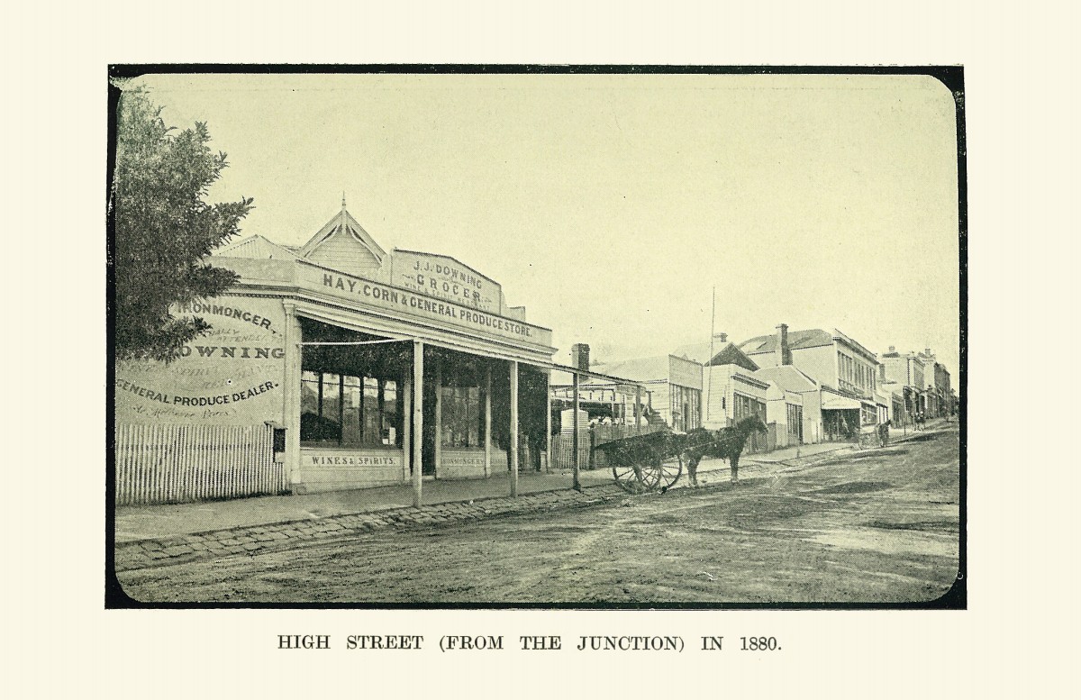 |
High Street (from the Junction) in 1880. |
The triangular block extending from the present Post Office corner, up each road as far as the cemetery and Glenferrie Road, portion 86 on the plan, was purchased by Samuel Watts, but was re-sold early in 1852 to a party of friends, Messrs. James V. Morgan, John Quick, Samuel Derrick, and William Derrick, who, hailing from the west of England, endeavored to give the name of Cotham, after their native village near Bristol, to the district, but Mr. Fenwick's name carried the day, and they had to be content with giving their favored name to the road forming the southern boundary of their purchase. Leaving out of consideration the farms around the Yarra frontage, the first house built in Kew proper «12» was that by Mr. Morgan in Charles Street, which he has occupied since January, 1852, and thus he can probably claim to be the oldest inhabitant of the district.
He relates that when endeavoring to fence in their block they had to clear a line for the southern boundary through a dense growth of wattles, so that when finished it had the appearance of a tunnel through the forest.
Among the first purchasers from Mr. Fenwick may be mentioned the Dannock family, father and two sons, James and Daniel, who have only recently passed away, leaving many representatives of the name. Their purchases were in the neighborhood of Pakington and Derby Streets. Messrs. J. J. French and James Day, other earl purchasers, are still represented in Kew by descendants bearing the same surname.
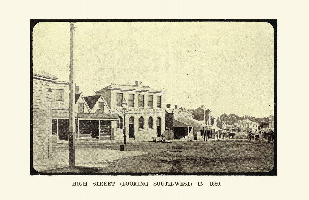 |
High Street (looking South-West) in 1880. |
Another of the early purchasers was Mr. Thomas Judd, who in December, 1852, purchased portion of Mr. Vaughan's block, and has resided on it ever since. He built his house on a rise overlooking a reserve, afterwards proclaimed a cemetery, and named it "Park Hill," on account of the park like character of the country between him and the Yarra. He had for an early neighbor Mr. James Bonwick, well known to writers on Australian history, who opened one of the first schools in the district.
A considerable area of Mr. C. Vaughan's purchase, portion 85, soon passed into the hands of the Ratten family, and has only recently come into the market again.
Portions 57, 58, 59. and 88, comprising about 480 acres for many years contributed greatly to the rural aspect of Kew, but about 1880 passed into hands of the Hyde Park Estate Company, and were cut up for re-sale. «13»

 |
 |